With some confusion regarding whether the Cooloola Recreation Area is a National Park and even what a Recreation Area is, below is some clarity regarding.
The general Cooloola coastal area stretches south of Wide Bay, from Rainbow Beach and Double Island Point extending to the west and south, including Teewah Beach stretching many kilometres to the south.
This area is covered by two government ‘designations’ – the Great Sandy National Park and the Cooloola Recreation Area. These cover different overlapping areas and have been established for different purposes.
Where is the Great Sandy National Park?
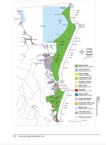
This national park covers both K’Gari and Cooloola combined. In practice because they are not connected, the two parts are listed separately on the Queensland Parks and Wildlife Service website as Cooloola, Great Sandy National Park and K’Gari, Great Sandy National Park. A map of the national park is attached below.
The Great Sandy National Park is designated a national park in the same manner as other national parks in Queensland.
What is a recreation area?
Recreation areas were introduced in 1998 to help manage increased recreation activity occurring on K’Gari at the time. As K’Gari was covered by national parks, state forests, beaches and mining leases, the new recreation area on the island allowed all these different types of land to be covered by one scheme.
This system has since then expanded and in 2010 the Cooloola Recreation Area has also been designated.
What is covered by the Cooloola Recreation Area?
It covers the multiple types of land tenure on Cooloola and incorporates:
- Cooloola, Great Sandy National Park
- The beach which is separate to the National Park
- Cooloola (Noosa River) Resources Reserve
- Great Sandy Resources Reserve
- Double Island Point Conservation Park
- Sheep Island Conservation Park
- Womalah Resources Reserve.
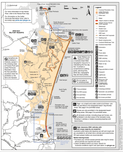
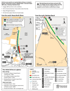
A map of the Cooloola Recreation Area is attached below.
How does a recreation area differ from a National Park?
A national park is established with the primary objective of the conservation of nature within the park.
A recreation area provides for the management and coordination of facilities and recreation. It allows for the issuing of vehicle access passes and camping permits, issuing permits for and controlling commercial activity, establishing restricted areas, and regulating fire and waste, as well as a range of other controls.
It is an overlay or addition to any national park designation, and the national park continues to be managed according to its conservation purpose.
Further Information
For those who would like to directly advocate with the Queensland Minster for Environment please do so via environment@ministerial.qld.gov.au. Please cc’ our office in via noosa@parliament.qld.gov.au and forward any response you receive to us.
For our previous Noosa 360 updates regarding Cooloola, please visit www.sandybolton.com/?s=Teewah
Updates on many local matters are available on Noosa 360 at www.sandybolton.com/noosa360. To receive information straight to your email inbox, please subscribe to our monthly newsletter via www.sandybolton.com/newsletters. This also ensures you receive any future Noosa related surveys or polls.
Map of Great Sandy National Park
Source: Great Sandy National Park Management Plan

Map of Cooloola Recreation Area
Source: QPWS CRA map


